Thursday, July 18, 2024

Rollin' Rollin' Rollin'

     Traveling mainly on Interstate highways has been a blessing.  Don't get me wrong, I thoroughly enjoy the scenic drives through the countryside but right now, It's all about getting back home.  Lynnville, Indiana has a very nice park considering the smallish size of the town.  The park is not very far from the highway but far enough that you don't get annoyed listening to highway noise all night.  The park itself is rather large and is outlined by a lake of sorts.  Its more like a swamp or delta in my mind but they call it a lake so, ok.  Anyway, The spot we had was right up front, not much to look at but it was shady, level, and had full hook-ups.  I took Toto and Bilbo for a walk through the park and discovered another area that was pure bliss.  Grassy meadows, Lots of old growth trees, away from all of the facilities and playgrounds, like a little piece of the forest all to yourself.  And like the forest, No hookups...  For just an overnight stop, I could do that.  If I was 20 years younger and packing a tent I'd book that for a week. Anyway, This was a decent overnight stop and lived up to our expectations for a local city park.


We left Thursday morning about 9 and headed for Kentucky again. That didn't make a lot of sense to me until I looked at the map.  This time headed more south than west, and almost entirely Interstate, except a section we avoided due to an accident that had happened over an hour earlier but was still causing traffic delays.  We arrived at Milan Tennessee about 3pm. and found our way to the Milan City Park.  This place is probably 200 acres or more, well maintained, has water and electrical hook-ups, nearly level gravel rv sites with grass, and a dump station on the way out. Another great choice for an overnight stop. They had a lot of activities going on so they gave us a spot away from the most of it and to top it off, The temps were mild with a nice calm breeze.


We're working out the drive time for Friday and deciding best routes.  We'll be leaving here a bit later than usual because we ran out of one of the prescriptions for Toto's Epilepsy and the pharmacy won't have it till after noon on Friday. We'll have it all figured out by then and I'll get another post up this weekend.  Thanks for sticking it out with us, I'll have news about our next RV Trek soon.  Cheers!

Tuesday, July 16, 2024

Homeward Bound

  After a little bit of exploration around the New River Gorge National Park and Fayetteville, WV. we decided to spend our Saturday relaxing in the campsite and planning the route to Boonesborough, KY.  This would be a bit longer distance than many of our previous drive days and we wanted to make good time of it without sparing the view.  Fortunately the geology and geography would provide both in abundance.  We followed RT 16 on our way out which was both beautiful and a slow twisty climb and decent along the gorge perimeter. Then up US 60 following the river as it divided the surrounding mountains till we reached Interstate 64.  As enjoyable as the scenic byways are they can be equally stressful driving a Motorhome towing a car.  Interstate 64 provided a little less scenery and a lot less stress.

We arrived at Fort Boonesborough State Park at 3:30 Sunday afternoon.  I was better prepared for this due to our experience in Kentucky State Parks last year.  The campsite we reserved was a Pull-thru with water and electric.  Kentucky State Parks decided at some point that providing water merely meant having a spigot available for 2 campsites to share, so you will find a water point between every other campsite.  That is an efficient way to use limited resources but without any knowledge of the Kentucky State Park system operations, I can testify that the planners have never gone camping in an RV.  Sure, when I was in my 20s, I was always on the lookout for a quiet tree covered site far from other campers where I could have a bit of privacy and enjoy the outdoors.  These parks seem to have been designed to incorporate the most sites they can fit in a given area without regard for the campers.  So, if you every decided to stop and stay at a Kentucky State Park with anything more than a tent, be sure to bring a very long water hose if you need such a connection.  I required 60 feet for my connection this time, thankfully the electrical connections are dispersed appropriately at this park, no extensions necessary.

There is no cell service available, at least not on our T-Mobile phones.  There are 2 towers clearly visible from our campsite, but a multitude of power lines running in all directions between here and there.  A three mile drive up the mountain in either direction will bring a concert of notifications, missed calls, voicemails, and updates as the cell phone tries to prioritize the immediate influx of data.  I am currently writing this blog in MS Notepad and will copy it over to the blog when I have the ability.  

The Park is not far from the city of Winchester, KY.  We had wanted to stock up on supplies after we got our campsite setup but the places we had planned to visit were closed on Sunday so we decided to make it out Monday morning instead.  Monday morning, we finished breakfast and eventually headed into town about 10:30.  With a list of items and possible locations, we made our way around town and got nearly everything we wanted.  The heat was already wearing on us and by now it was well past lunch time so we picked up some Italian to go and sat down to lunch at the campsite around 3:30.  Where had the time gone?  It was 96 with a heat index somewhere near 110.  The air conditioner in the RV was unable to cool us below 83.  I think I will climb up and put some gauges on it after we get home.

With equally abrasive heat indexes today, we're staying inside.  I'm sitting here in my shorts writing the blog and Lynn is catching up on here internet addiction essentials.  Wait, What? OK, let me back up a moment.  Sitting down at my laptop earlier, I wanted to get something up on the blog since I'm sure those few who have been following along were beginning to wonder.  Being the Tech-Geek I am, I decided to scan and look for any possible unsecured networks I could hop onto.  The only thing I could find was a dreadfully slow Wireless-G network with only 1 bar.  It turned out to be a pay as you go connection for the campground.  I was expecting it to get better once payment was made but no...  Not only was it slow, but the moment I gave the login info to Lynn, a webpage popped up notifying her that the connection to the network was already occupied by the one and only device allowed for the connection.  Suffice it to say, I removed my IP and input Lynn's.  Writing the blog didn't require internet until it was ready to post and Lynn had a lot of messages and emails to catch up on.

When I caught the news yesterday, It looked like there was a cold front coming in from the northwest that might provide some relief this evening.  Just the spotty clouds have been enough to help the AC keep up better today, and although its still hot, there has been a light breeze out of the east foretelling the cool front to come.  It's 2pm now and 94 degrees outside.  I spent the last hour walking around this end of the campground and looking for something of a more pleasant campsite.  Got back inside to finish the blog, Georgie Girl is hanging in there at 77 degrees inside, not great but a clear relief after being outside.  All of the campsites here have 1 drawback or more.  A good campsite would be nearly level with shade, and water and power close at hand.  I was only able to find one campsite that approached that criteria but still lacked easy access to water.  

The purpose of this stop was two fold.  Something in the general direction of home with a general source of interest, and a three day stay to relax before a few  back to back driving days.  It has served it's purpose in general.  Fort Boonesborough was established in 1775 by Daniel Boone after several explorations into Indian territory, a frontier now known as Kentucky.  The fort was actually a community of settlers, their homes forming the outer walls of the fort.  Soon after, the first legislative assembly of frontier settlers led by Col. Richard Henderson under what is known as the "Devine Elm" outside of the fortification.  Literally nothing of that fort remains today.  The fort was abandoned in 1778 after a Shawnee attack and the settlement was abandoned altogether by 1820. The original site has been searched for and a little archeological research has provided some small remnants.  A reconstruction has been built nearby and several monuments have been erected near what is considered the original location.  


We'll leave here in the morning on our way to Lynnville, Indiana for an overnight stop at a small city par there.  Experience has taught us that it's the small city parks where you find some of the best sites, not necessarily the most private but usually better maintained and thoughtfully appropriated.  There's no way to know just yet but we'll know soon enough and be out on the road again heading for another city park next morning.  I'm not sure what time and/or accommodations will be available to me but I will update again when I can. Cheers!

Friday, July 12, 2024

New River Gorge National Park

     Bear with me as I attempt to bring you along whilst trying not to sound like some travel brochure.  A couple of years ago, before we bought the RV, we were on our way home and drove through this area.  After driving it, and checking it out a little more, we were convinced it was worth a deeper look.  Until then, I hadn't even heard of the New River Gorge.  We're here for 2 full days this trip and after today, I can imagine coming out for an entire week although I don't really have the stamina to do all there is to do here.  

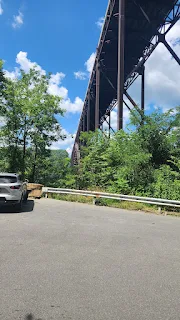
We've Driven across the bridge a few times, and although it's a beautiful view, we've been surrounded by beautiful views for a couple weeks now.  You'll want to be in the outside lane to enjoy the view, but you'll really appreciate it from the bottom of the gorge. I'm really gonna keep this post short and just let the pictures tell a thousand words.

New River Gorge Bridge

View from boardwalk observation deck.


About half way down the gorge on a 1 lane road.

That's a 69 foot wide highway, 876 feet above the river spanning 3,030 feet across


I was getting a little vertigo trying to get this shot.


A broader perspective from the bottom of the gorge. (not my pic)
There is a single lane bridge at the bottom of the gorge, it's how folks got across the river before the new bridge was built.  88 Million pounds of steel.


An finally from the other side of the river at the area where the rafters launch from.

We'll try to explore a little more, I'll let you know what we find in the next post.
Cheers!

Thursday, July 11, 2024

Skyline drive and beyond

     We stayed at an Army Corps of Engineers campground in Confluence, PA Wednesday, Unfortunately there was zero signal available for anything other than emergency calls.  The trip was ok, nothing too breathtaking or concerning to report.  I can say we will never go there again.  The Outflow Campground was fine, but getting there and out again just wasn't worth it. I've always thought of this region as Rolling hills, Wrong. This area is a lot like the ozarks, but on steroids. I asked myself,"Why would anybody even consider laying down pavement on an 18% grade"?  

So for a quick catch up, We completed Skyline Drive at Front Royal Virginia, Due West of Washington DC. From there we proceeded northeast through Maryland and into Pennsylvania stopping at Confluence.  The following pictures are from that transit.


This was the first overlook after leaving camp with a view, I couldn't resist the clouds floating across.


It wasn't long before we were driving through the clouds, and the views disappeared. I didn't get any more photos after that. We proceeded north staying at Confluence, PA overnight, then following the National Pike past Braddock's Grave and stopped to visit the Fort Necessity National Battlefield. For those of you who don't know the significance, Google it.  I'll just say it's all obscure history today, but fascinating to learn.


Another Item Checked off the bucket list.  From there we headed south and stumbled upon a scenic overlook with a Marker sign.  Honestly, I was just worn out and saw an opportunity to pull off and take a break.  Bonus.


OH, and of course the View of the overlook below.  We passed Youngs Monument Road after we left here.


Right now we are staying at the Rifrafters Campground by the New River Gorge in West Virginia.  We will be here for 3 days so I can't say when my next post will be but I'll have plenty to share when I do.  Thanks for following along, I really enjoy the comments.  Until next time, Cheers!

Tuesday, July 9, 2024

Skyline Drive

 We arrived at the Big Meadows Campground yesterday afternoon.  This campground is quite large with over 200 campsites and is operated by the National Park Service.  There are no hookups, and generator use is limited to a few hours in the morning and evening. Skyline Drive runs through the Shenandoah National Park from Waynesboro, VA to the north end of the Shenandoah National Park just outside of Front Royal, VA. 

Skyline drive is only 105+ miles long, 2 lanes wide, with a speed limit of 35 mph the entire length.  Unlike the Blue Ridge Parkway, signs for each overlook are on the roadway before the entrance, thus I was unable to capture the overlook with a descriptive sign.  There were far too many pull-offs/overlooks we passed that were nothing more than small parking areas with nothing more to see than the forest around them.  The first stop we did make was called Ravens Roost Overlook and the view was so expansive I had to take a panoramic photo.  

All photos can be viewed full screen just by clicking on them.  In order to truly enjoy them, when you are on the full screen photo display, Right click on a photo and open it in a new tab, this will still only open up at screen size but your mouse will now be a magnifying glass and a left click will show you the full 4k+ image to explore.


You will take note of the parking area visible on the left, I must confess, I had no idea when I pulled into this overlook that it didn't have another exit and I was forced to wait for all the other tourists to leave before driving up onto the sidewalk in order to make a U-turn at the end.  Thankfully, that provided just enough space to complete the u-turn without having to disconnect the car and dolly.


Unfortunately, I just don't recall which overlook this one was, but like most of the shots we've taken for the past week, we pull up to an overlook, exclaiming "Oh my God", then hope a photo will capture some semblance of the experience and move on to the next.

We arrived at the Big Meadows Campground shortly before 6pm last night. found out we only had an hour left to make dinner and shut off the generator by 7pm.  At first this seemed a bit inconvenient, But in retrospect it was a nice experience.  We don't often camp at sites without at least water and electric, but the generator allows us to broaden our options and we really wanted to spend time in the campgrounds within the parks as much as possible instead of getting off and driving 20 miles away.

We shut the generator down at 7 pm and opened up all the windows and ceiling vents,  then moved outside to our lounge chairs and the peace and tranquility sank in.  Later when we went to bed, it was the most quiet evening of the entire trip, and we'll have another like it tonight.  No air conditioner, no tv, no anything.  And as we sat enjoying the evening, A doe calmly walked past our campsite not more than 20 feet away grazing on the grasses and forest floor plants.  I wanted to get a picture but I had left my phone in the rv and wasn't going to disrupt the moment.  Today, She came back and gave me another chance.


That's all for today.  Tomorrow we're completing Skyline Drive and continuing north to Confluence, PA


Monday, July 8, 2024

Blue Ridge Parkway - Day 7

 We came to the end of the Blue Ridge Parkway and drove down into Waynesboro,  VA for supplies.  Then back up the mountain to the junction of the Parkway and Skyline Drive.   We are staying at the Big Meadows Campground on Skyline Drive in the Shenandoah National Forest for 2 nights.  I'm posting this from my cell phone so I'll close out here and add a few pics for good measure. 


So long for now.  Hopefully I'll get another posting up tomorrow from the laptop.   Cheers!


Sunday, July 7, 2024

Blue Ridge Parkway - Day 6

    Today was to be another easy day, 100 miles of travel.  We had no trouble setting out, just raise the landing gear and go.  Murphy's Law has always demanded respect and I have paid my respects as often as any other.  After a time, we had stopped for a few photo ops and had a chance conversation with another couple on the parkway who were traveling south and mentioned a road closure ahead for us.  I had expected signs and a routed detour but never saw any.  Then, at an exit point all of the sudden, the gates were closed on the North side so we got off.

    There was a vibration in the front end I had noticed but sloughed off thinking it was nothing more than the road surface.  Turns out I'm not entirely sure what it is, but if I'm driving on a straight section of roadway, between 30 and 45 mph., and hit a bump or a pothole, the front wheels will begin wobbling left and right. If I ignore it, it will grow in intensity till it's out of control.  A simple mash on the brakes will stop it.  I have considered many possible causes, most prominently expecting a bad drag link in the steering but I crawled underneath and checked every linkage finding all in good condition.  I can only assume now, after driving so far and deeply focused on the issue, that the right front tire, or both tires need to be balanced.  And since the front end alignment has never been perfect, might as well schedule all of the above for service.  For now, I'm aware and able to manage it till we get home. (crosses fingers)...

    To be brief, our simple drive day, turned into a 9 hour day.  To be fair, I did spend nearly an hour Hiking half a mile down the side of a mountain and back.  We wasted another hour searching out a gas station, and right up to the end, I missed the turn to the campground only to find the next exit was almost 10 miles away before we could turn around and go back.  The endless Vistas make it all worth it, I only wish the photos could convey this, Enjoy them as you wish, and remember, click on any picture to review it full screen.  Cheers!


Saturday, July 6, 2024

Blue Ridge Parkway - Day 5

 We planned to set out early with expectations of getting underway by 8:30.  At 9:30 we started rolling.  At least I didn't have any stops to make early on and the traffic was light enough that I didn't need to pull off very often to let others pass.  I was ready to pull off by 10:30 already tired and needing a break as the road was in poor condition and was fraught with tight corners and steep climbs and descents.  We had traveled 22 miles and my long travel day expectations were now gnawing at my patience.  An hour later we stopped again and I took a break, 24 miles this time.  We decided to go ahead and make lunch as long as we were already stopped.

Back on the road and making better time but soon we came across detour signs indicating construction ahead with that area closed to traffic.  Much needed construction if it was anything like the last 50+ miles I'd seen.  We got off the parkway at Hwy 16 and followed the signs.  A little relief knowing I could now drive 55 on most of the route although there were a few areas that tested me hard and I would highly recommend construction to repair the roadbed.

We re-entered the Parkway at Mile Marker 217, less than a half mile from the Virginia State Line, and OH, MY, GOD...   The Parkway was now as smooth and well constructed as the views.  The speed limit was still mostly 45 but every curve was rated for at least 45 and none of the grades were excessive.  Driving the next 50 miles to the campground was and enjoyment again.  Now it seemed we were going to arrive before the designated check-in time and so I was free to stop and get a few more of those beautiful photo opportunities.


We pulled into the Rocky Knob Campground at about 3:10 and made our way to the campsite.  Ugh, I spent the better part of an hour trying every option I could manage just to get the RV level.  I gave up after several failed attempts and proceeded around the campground loop again looking for another site that I could both fit into and get level.  Two other sites were promising but the first one was still not level enough and the second was reserved.  I drove back to the gate and chatted with the ranger.  I made one more round and found the perfect site. It's already 4:30 but I'm in, Level, and set to get started prepping for dinner. 

There are no hookups here and we are limited to running the generator until 10pm.  Nicely enough, at this elevation, it was nice and cool by 7 and we opened up the windows and I sat down to put todays post together.  Cell signal varies between 1 Bar of LTE and 3 Bars of 5G.  Hopefully, I'll get this uploaded before anybody thinks I've driven off the side of a mountain.

    We've only got about 100 miles to our next campground stop. It's a KOA Campground, so I'll probably have a good signal and update ya'll a little earlier.  Lynn and Toto said Hey!  


HAPPY BIRTHDAY ANDREA

Friday, July 5, 2024

Blue Ridge Parkway - Day 3&4

    We're Staying at the Bear Den Mountain resort and campground on the Blue Ridge Parkway at Mile Marker 324.8, The town of Spruce Pine is not far away and we went into town to replenish groceries this morning.  But I'm getting ahead of myself.  Yesterday was July the 4th, and our first full day here.  We did take a little trip into town just to have a little look-see.  Yep, it's a quaint little mountain town.  We got back to the campsite, made lunch and settled down, which at my age means we took a nap. 

    Being the 4th of July, it was much different than those at home.  Different in that at home, I have already been desensitized to the sound of firework for the past week and tonight would be the culmination of that with an abrupt tapering off next day.  Here on the Parkway, Quiet, Peaceful, and if you listen closely you might here a pop or two in the distance.  Not wanting to blow off the celebration entirely, I decided it might be a good idea to watch what the local townships might be putting on nearby.

    I have no idea where to go but with the wide variety of overlooks on the parkway, I turned south to try and find a good vantage point.  I think I stopped at the Black Mountain overlook but I'm really not sure.  We pulled in at  about 10 till 9 and a couple of other cars were stopped here already with a few more to follow as well.  We sat and waited and not long after 9 the show began.  Shows that is, from our perched perspective, we watched the fireworks displays of five different communities.  Unfortunately these fireworks displays were so distant that it was little more than a twinkling of colored lights against a vast mountainous backdrop we peered at.

    Looking ahead, we will be staying at the Rocky Knob Campground on the Parkway roughly at Mile Marker 167.  Now 158 miles seems like a short hop especially if you consider we've already put over 1000 miles behind us since we left home.  But, we only average about 30 miles an hour on the parkway so that puts me in the driver's seat for a little over 5 hours.  Add in the photo ops and it tally's up to be a very long day of travel.  The campground is primitive, meaning NO, water or electric. Now THAT is camping, or at least a lot closer to what I considered camping 20 years ago.   

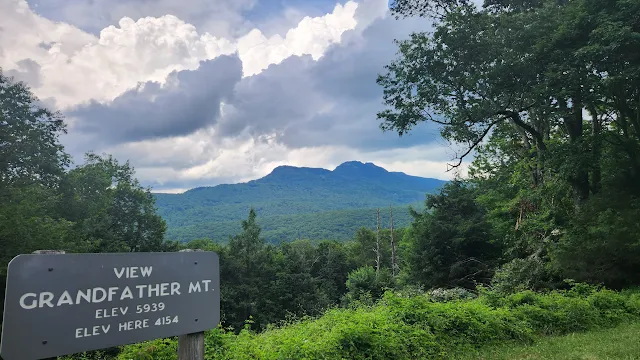
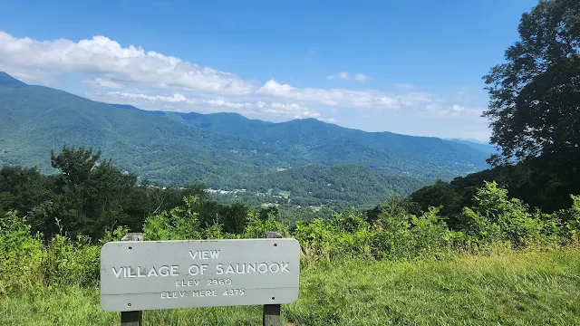
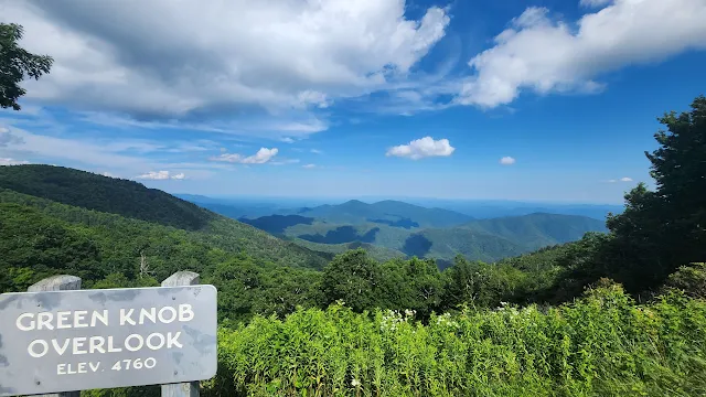
    Earlier, you'll recall our little jaunt into town today for supplies.  When we got back, we unloaded the groceries and proceeded a little further north on the Parkway in the car to get a preview of the road ahead and take a few pics while there was plenty of daylight.  We'll try to get started early tomorrow and now won't need to make any  photo stops early on.  So below are the upcoming overlooks we shot today.


Is there a Playboy retreat down there somewhere?


The last shot above was taken at an un-named overlook, that or I missed the sign. 
It had started raining and I wanted to capture the clouds above and below.

     I'm sure there will be plenty more to follow, check back anytime to catch up.  Cheers!

Wednesday, July 3, 2024

Blue Ridge Parkway - Day 2

    Another day on the Parkway and plenty of pictures of the trek.  Getting out of Waynesville was fun, NOT.  We went into town to get gas before heading out and found a BP station cheaper than all the other stations in town and just a few blocks away from the main thoroughfares. Not a very big station, Only had 4 pumps and all were full when we arrived.  I waited patiently parked out of the way so as not to block customers from entering the storefront.  Saw one car pull out and the car behind started to pull away so I began to move towards the pumps.  Nope, the second car just did an about face cause she was too #%&@# to know which side of her car to put the fuel into.  Now I'm blocking the storefront.....  and three more cars jumped in line to fill spots.  Decided it was worth the price to just go to a big station and get going.  

    Drove out to the main drag, and got into the turn lane to make a left into the Ingles Parking lot.  The lanes were really narrow, I was hanging the tires on the yellow line but Clipped the mirror on a big pickup truck in the lane to my right who likely felt just as snug is his lane as well.  We both exchanges shrugs, not much else we could do except block more traffic and probably cause some real problems.  We both drove our separate ways and I finally got Georgie Girl filled up and ready for the next leg of the Parkway.  We re-entered the Parkway just Southwest of Waynesville at Balsam.

Today's Parkway travel was about 120 miles. The speed limit was 45 mph for most of it and 35 mph for about a quarter of it. Regardless of the limit, We traveled along at 35 mph and stopping at a lot of the pull-offs and overlooks allowing others to pass.  On the downhill slopes, I would allow Georgie Girl to get up to as much as 50mph since there was no fuel cost, but rarely able to do it due to the bumps and curves.  Enough of this, Pictures below of each of the stops we made that had a view worth photographing.  

No sign on the first pic, but it's looking out over the highway we had just gotten off of to enter the parkway.


The Roy Taylor Forest Overlook also had a short trail the went off to the left and out to a sky platform. 
The next pic was taken from there.
And one of the High Points of our journey, ...sorry, couldn't resist. :-)
 
The next shot is looking at the rock face behind me when I took the above shot at Caney Fork Overlook.


A view from the driver's seat as we approach one of the tunnels. All of which today were high enough to permit Georgie Girl to transit in her own lane.


The Cradle of Forestry Overlook.  We had minutes before this, passed by the entrance to the museum but time was running short and we had to pass it by.

Never stop learning, lest ye die.


That's all for today, We stopped at Bear Den Mountain resort and campground on the Blue Ridge Parkway.  We'll be here for the 4th of July and take another day's break before continuing on.  Cell service here is next to zero and the Wi-fi left much to be desired, so we got a premium Wi-fi package for 3 days to satisfy our habit and to keep the blog going.  We'll likely do a little exploring in the area while we're here and I'll post anything of interest should that happen.  *** Happy Independence Day! ***

Belle Starr RV Park

 Saturday, March 1st 2025 Our last stop on the road home. On the shores of Lake Eufaula in Oklahoma at the Belle Starr Corps of Engineers RV...